- News
- India News
- India’s green cover rises, touches nearly one-fourth of geographical area: Report
Trending
This story is from January 14, 2022
India’s green cover rises, touches nearly one-fourth of geographical area: Report
India’s green cover has touched nearly one-fourth of its geographical area with "forests" and "trees outside recorded forest areas" put together recording an increase of 2,261 sq km (0.3%) in 2021 compared to the previous assessment in 2019, shows the latest India State of Forest Report (ISFR 2021) released on Thursday.
NEW DELHI: India’s green cover has touched nearly one-fourth of its geographical area with "forests" and "trees outside recorded forest areas" put together recording an increase of 2,261 sq km (0.3%) in 2021 compared to the previous assessment in 2019, shows the latest India State of Forest Report (ISFR 2021) released on Thursday.
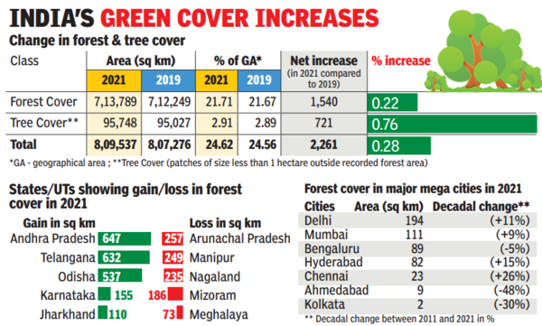
The total green (forests and trees) cover has now reached 8,09,537 sq km (24.6% of geographical area), which includes 7,13,789 sq km of forest cover — 21.7% of the area.Overall, forest cover has recorded an increase of 1,540 sq km (0.2%) while tree cover increased by 721 sq km (0.8%) in the past two years.
Releasing ISFR 2021, environment minister Bhupender Yadav emphasised on the government's priority to focus not just on increasing/conserving the forest cover quantitatively but also enriching it qualitatively, and noted that 17 states/UT’s have above 33% of the geographical area under forest cover.

ISFR 2021 shows that five states/UTs — Lakshadweep, Mizoram, Andaman & Nicobar Islands, Arunachal Pradesh and Meghalaya — have more than 75% forest cover while 12 states/UTs — Manipur, Nagaland, Tripura, Goa, Kerala, Sikkim, Uttarakhand, Chhattisgarh, Dadra & Nagar Haveli and Daman & Diu, Assam, Odisha — have forest cover between 33% and 75%.
Overall, the increase in forest cover has, however, been mainly observed in the "open forest" category followed by "very dense forest". Forest cover includes all land more than one hectare in area with a tree canopy density of more than 10%. Land with a tree canopy density of 70% and above is classified as "very dense forest (VDF)" while land with a canopy density of 10% and more but less than 40% is classified as "open forest (OF)".
Similarly, land with a canopy density of 40% and more but less than 70% is put under the "moderately dense forest (MDF)" category, which, in fact, reported a decline of 1,582 sq km in 2021 compared to 2019. In addition to the three density classes, scrub areas (forest lands with a canopy density of less than 10%) have also been classified and mapped. But scrub areas are not part of the forest cover.
The top three states showing an increase in forest cover are Andhra Pradesh (647 sq km), Telangana (632 sq km) and Odisha (537 sq km). Area-wise, Madhya Pradesh has the largest forest cover in the country followed by Arunachal Pradesh, Chhattisgarh, Odisha and Maharashtra. In terms of forest cover as percentage of total geographical area, the top five states are Mizoram (84.5%), Arunachal Pradesh (79.3%), Meghalaya (76%), Manipur (74.3%) and Nagaland (73.9%).
The report provides information on forest cover, tree cover, mangrove cover, growing stock, carbon stock in India’s forests, forest fire monitoring, above-ground estimates of biomass using satellite data and climate change hotspots in Indian forests. The forest and tree cover areas have been derived from complete wall-to-wall mapping of the country’s forest cover using remote sensing techniques, sample plot-based national forest inventory and special studies carried out at the national level.
The Forest Survey of India, which prepared the report, claimed that the satellite data interpretation is followed by rigorous ground truthing. "Information from other collateral sources is also used to improve the accuracy of the interpreted image. The accuracy level achieved in the current assessment is significantly high," said the environment ministry.
It claimed that the accuracy of forest cover classification has been assessed at 92.9%. "The accuracy of classification between forest and non-forest classes has been assessed 95.8% against internationally accepted accuracy of classification of more than 85%," said the ministry.
The biennial report has also for the first time included a special chapter on forest cover assessment in tiger reserves, tiger corridor areas, lion conservation areas and in seven major cities — Delhi, Mumbai, Bengaluru, Hyderabad, Ahmedabad, Chennai and Kolkata. It is seen that Delhi has the largest forest cover, followed by Mumbai and Bengaluru.
The latest assessment also shows an increase of 17 sq km in total mangrove cover (4,992 sq km in 2021) in the country as compared to the previous assessment. The top three states showing mangrove cover increase are Odisha (8 sq km), Maharashtra (4 sq km) and Karnataka (3 sq km).
The total green (forests and trees) cover has now reached 8,09,537 sq km (24.6% of geographical area), which includes 7,13,789 sq km of forest cover — 21.7% of the area.Overall, forest cover has recorded an increase of 1,540 sq km (0.2%) while tree cover increased by 721 sq km (0.8%) in the past two years.
Releasing ISFR 2021, environment minister Bhupender Yadav emphasised on the government's priority to focus not just on increasing/conserving the forest cover quantitatively but also enriching it qualitatively, and noted that 17 states/UT’s have above 33% of the geographical area under forest cover.
Yadav also underlined India's commitment to increase green cover, and reminded what Prime Minister Narendra Modi had promised at the UN climate conference (COP26) in Glasgow (UK) in November last year when he appealed to world leaders to focus on LIFE (Lifestyle for Environment) as a joint global campaign for a sustainable future.
ISFR 2021 shows that five states/UTs — Lakshadweep, Mizoram, Andaman & Nicobar Islands, Arunachal Pradesh and Meghalaya — have more than 75% forest cover while 12 states/UTs — Manipur, Nagaland, Tripura, Goa, Kerala, Sikkim, Uttarakhand, Chhattisgarh, Dadra & Nagar Haveli and Daman & Diu, Assam, Odisha — have forest cover between 33% and 75%.
Overall, the increase in forest cover has, however, been mainly observed in the "open forest" category followed by "very dense forest". Forest cover includes all land more than one hectare in area with a tree canopy density of more than 10%. Land with a tree canopy density of 70% and above is classified as "very dense forest (VDF)" while land with a canopy density of 10% and more but less than 40% is classified as "open forest (OF)".
Similarly, land with a canopy density of 40% and more but less than 70% is put under the "moderately dense forest (MDF)" category, which, in fact, reported a decline of 1,582 sq km in 2021 compared to 2019. In addition to the three density classes, scrub areas (forest lands with a canopy density of less than 10%) have also been classified and mapped. But scrub areas are not part of the forest cover.
The top three states showing an increase in forest cover are Andhra Pradesh (647 sq km), Telangana (632 sq km) and Odisha (537 sq km). Area-wise, Madhya Pradesh has the largest forest cover in the country followed by Arunachal Pradesh, Chhattisgarh, Odisha and Maharashtra. In terms of forest cover as percentage of total geographical area, the top five states are Mizoram (84.5%), Arunachal Pradesh (79.3%), Meghalaya (76%), Manipur (74.3%) and Nagaland (73.9%).
The report provides information on forest cover, tree cover, mangrove cover, growing stock, carbon stock in India’s forests, forest fire monitoring, above-ground estimates of biomass using satellite data and climate change hotspots in Indian forests. The forest and tree cover areas have been derived from complete wall-to-wall mapping of the country’s forest cover using remote sensing techniques, sample plot-based national forest inventory and special studies carried out at the national level.
The Forest Survey of India, which prepared the report, claimed that the satellite data interpretation is followed by rigorous ground truthing. "Information from other collateral sources is also used to improve the accuracy of the interpreted image. The accuracy level achieved in the current assessment is significantly high," said the environment ministry.
It claimed that the accuracy of forest cover classification has been assessed at 92.9%. "The accuracy of classification between forest and non-forest classes has been assessed 95.8% against internationally accepted accuracy of classification of more than 85%," said the ministry.
The biennial report has also for the first time included a special chapter on forest cover assessment in tiger reserves, tiger corridor areas, lion conservation areas and in seven major cities — Delhi, Mumbai, Bengaluru, Hyderabad, Ahmedabad, Chennai and Kolkata. It is seen that Delhi has the largest forest cover, followed by Mumbai and Bengaluru.
The latest assessment also shows an increase of 17 sq km in total mangrove cover (4,992 sq km in 2021) in the country as compared to the previous assessment. The top three states showing mangrove cover increase are Odisha (8 sq km), Maharashtra (4 sq km) and Karnataka (3 sq km).
About the Author
Vishwa MohanEnd of Article
FOLLOW US ON SOCIAL MEDIA


Hot Picks
TOP TRENDING
Trending Stories
In India
Entire Website
- Best Gaming Laptops In India: Top Picks In Every Budget For Different Gaming Needs
- JAC 10th Results 2024 Live: Jharkhand board Matric result today on jacresults.com
- IPL Today Match LSG vs CSK: Dream11 prediction, head-to-head stats, fantasy prediction, key players, pitch report and ground stats of IPL 2024
- Israeli missiles hit site in Iran, explosions heard at airport: Key points
- Meet Vasuki Indicus, the ‘crocodile’ that was a 50ft snake
- Maharashtra speaker Rahul Narwekar creates stir in BJP, says he’s in don Arun Gawli’s gang now
- Apple iPhone 13 available for just Rs 15,336 on Amazon; check out the offer details
- Best 75 inch Smart TVs in India: Top Picks For A Premium Viewing Experience
- LSG vs CSK: Is Mayank Yadav fit to have a go at MS Dhoni & Co? Here's an update
- Watch - 'Isiliye tika laga ke aya': When Shardul Thakur missed wishing KL Rahul 'Happy Birthday'
- ‘Largest-ever': Meet Vasuki indicus, the ‘croc’ that was a 50ft snake
- Phase 1 LS polls: 'Substantial' turnout till 1pm, says EC
- Who is this dreaded gangster hell-bent on killing Salman Khan?
- Air India suspends all flights to and from Tel Aviv till April 30
- It’s battle royale: Hisar to see clash of 3 Chautalas
- 'Can we get more of MS Dhoni?' asks MSD fan Steyn
- Will Apple help India become a high-tech manufacturing hub?
- Google employees protest Israel project: What CEO Sundar Pichai said
- LS polls: One village's polling officers are all women
- Now, a Kerala Story by pro-Sangh body

Popular Categories
Hot on the Web
Top Trends
Jasprit BumrahArvind KejriwalJAC 10th ResultTamil Nadu Lok Sabha ElectionIsrael Iran War NewsLok Sabha Election Phase 1IPL Today MatchStock MarketIPL Live ScoreBest AC Brands in IndiaIPL Orange Cap 2024IPL Purple Cap 2024IPL 2024 ScheduleLok Sabha Election Full ScheduleIPL Points TableIPL Match Full Schedule
Trending Topics
Bade Miyan Chote Miyan CollectionAR RahmanDeepika PadukoneBalram Mattannur Death NewsRam Temples In IndiaDubai FloodSamarth JurelRam Lalla OutfitAnushka SharmaMasaba Gupta Pregnancy NewsShilpa ShettyJennifer Mistry Bansiwal Sister DeathDibakar BanerjeeArticle 370 OTT ReleaseHappy Relationship TipsNita AmbaniBest 4TB Hard DiskBest Dishwashers In IndiaBest 75 Inch Smart TvBest Gaming Laptops
Living and entertainment
Latest News
Kerala: Polling officials suspended over interference in voting at elderly woman's home in KannurMan held for molesting woman on moving train in KeralaSalman Khan's 'Jaanam Samjha Karo' co-star Grusha Kapoor reveals he was once 10 hours late on the set: 'Nobody had the courage to tell him''Professor Jasprit Bumrah should hold bowling lectures'Gold price surge impact: Indian jewellers now betting on diamond jewellery in 14-carat goldSouth Korea government offers first compromise in effort to end doctors' strikeSTATS STACKEnvoy says US is determined to monitor North Korean nukes, through UN or otherwiseDubai Airports urges passengers not to arrive at the airport unless flights are confirmedFrom a lavish home in Poes Garden to luxurious cars, Dhanush's net worth peaked well in the last few yearsQ&A: Mastectomy vs conservation: What’s best for breast cancer patients?Samantha Ruth Prabhu's podcast explains freeze response drawing parallel from Allu Arjun starrer 'Pushpa' filmFormer T-ARA member Ahreum ends relationship with boyfriend amidst controversiesCredit limit, billing cycle and 10 other important credit card terms you must knowTaiwan says new Chinese air routes threaten Taiwanese islands' flight safetyWhy BJP needs more than a half-century in south to hit ‘400’ in Lok Sabha electionsLok Sabha Elections 2024 in Haryana: Schools and colleges will remain closed on this dateSuper Junior’s Ryeowook slams online hate comments
Copyright © 2024 Bennett, Coleman & Co. Ltd. All rights reserved. For reprint rights: Times Syndication Service